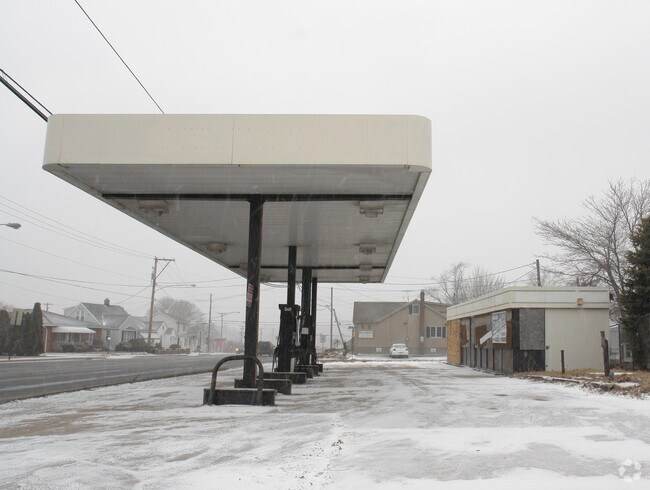
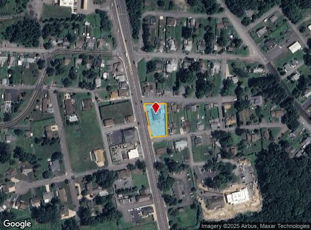
Property Record
30 W 7Th St, Hazleton, PA 18201

NEARBY LISTINGS FOR SALE OR LEASE
Property Detail
30 W 7Th St
Scranton--Wilkes-Barre--Hazelton, PA
Nelly Holdings Inc Reverse Subdivision
26-S8S5-014-001-000
26-1-846-10 THIRTY-SEVENTH ST
Supermarket
Luzerne
X
Pennsylvania
42079C0626E
1
2025
0.48 AC
2025
I-81 Corridor
217600
Philadelphia
DEMOGRAPHICS near 30 W 7Th St
1 Mile
3 Mile
5 Mile
2024 Total Population
2,845
40,864
59,092
2029 Population
2,796
40,615
58,712
Pop Growth 2024-2029
(1.72%)
(0.61%)
(0.64%)
Average Age
47
39
40
2024 Total Households
1,200
15,260
22,792
HH Growth 2024-2029
(1.75%)
(0.60%)
(0.66%)
Median Household Inc
$54,666
$45,335
$53,520
Avg Household Size
2.20
2.60
2.50
2024 Avg HH Vehicles
2.00
1.00
2.00
Median Home Value
$193,181
$129,087
$141,799
Median Year Built
1976
1954
1958
Nearby Places
Map Layers
Map Styles
 Street
 Aerial
- Restaurants
- Banks
- Shops
- Fitness
- Groceries
PUBLIC TRANSPORTATION
AIRPORT
Wilkes-Barre/Scranton International
DRIVE
WALK
Distance
Wilkes-Barre/Scranton International
41 min
31.5 mi
Nearby Properties
Address
Land Use
TOTAL SIZE
Lot Size
Zoning
Address
Land Use
TOTAL SIZE
Lot Size
Zoning
75.45 AC
Address
Land Use
TOTAL SIZE
Lot Size
Zoning
59.39 AC
Address
Land Use
TOTAL SIZE
Lot Size
Zoning
17.47 AC
Address
Land Use
TOTAL SIZE
Lot Size
Zoning
529.84 AC
Address
Land Use
TOTAL SIZE
Lot Size
Zoning
33.38 AC
Address
Land Use
TOTAL SIZE
Lot Size
Zoning
14.15 AC
Address
Land Use
TOTAL SIZE
Lot Size
Zoning
8.29 AC
Address
Land Use
TOTAL SIZE
Lot Size
Zoning
19.82 AC
Address
Land Use
TOTAL SIZE
Lot Size
Zoning
33.73 AC
Address
Land Use
TOTAL SIZE
Lot Size
Zoning
10.83 AC
Address
Land Use
TOTAL SIZE
Lot Size
Zoning
Address
Land Use
TOTAL SIZE
Lot Size
Zoning
12.21 AC
Address
Land Use
TOTAL SIZE
Lot Size
Zoning
Address
Land Use
TOTAL SIZE
Lot Size
Zoning
25.48 AC
Address
Land Use
TOTAL SIZE
Lot Size
Zoning
12.25 AC
Address
Land Use
TOTAL SIZE
Lot Size
Zoning
14.10 AC
Address
Land Use
TOTAL SIZE
Lot Size
Zoning
Address
Land Use
TOTAL SIZE
Lot Size
Zoning
0.72 AC
Address
Land Use
TOTAL SIZE
Lot Size
Zoning
Address
Land Use
TOTAL SIZE
Lot Size
Zoning
4.56 AC
Address
Land Use
TOTAL SIZE
Lot Size
Zoning
15.30 AC
Address
Land Use
TOTAL SIZE
Lot Size
Zoning
0.34 AC
Address
Land Use
TOTAL SIZE
Lot Size
Zoning
33.40 AC
Address
Land Use
TOTAL SIZE
Lot Size
Zoning
5.10 AC
Address
Land Use
TOTAL SIZE
Lot Size
Zoning
2.70 AC
Address
Land Use
TOTAL SIZE
Lot Size
Zoning
Address
Land Use
TOTAL SIZE
Lot Size
Zoning
Address
Land Use
TOTAL SIZE
Lot Size
Zoning
19.60 AC
Address
Land Use
TOTAL SIZE
Lot Size
Zoning
16.89 AC
Address
Land Use
TOTAL SIZE
Lot Size
Zoning
9.45 AC
The World's #1 Commercial Real Estate Marketplace
Connect with us
© 2025 CoStar Group
The information above has been obtained from sources believed reliable. While we do not doubt its accuracy we have not verified it and make no guarantee, warranty or representation about it. It is your responsibility to independently confirm its accuracy and completeness. Any projections, opinions, assumptions, or estimates used are for example only and do not represent the current or future performance of the property. The value of this transaction to you depends on tax and other factors which should be evaluated by your tax, financial, and legal advisors. You and your advisors should conduct a careful, independent investigation of the property to determine to your satisfaction the suitability of the property for your needs.